Arecibo Observatory!
Second Largest Radio Astronomy Telescope
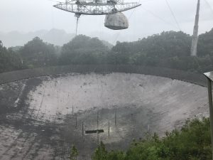
Today we made the arduous journey up through the mountainous rain forests of Puerto Rico to the Arecibo Observatory, the largest radio telescope in the world. Well, as of ten months ago, now the second largest. It was pretty cool to visit this observatory where they mainly do radio astronomy, measuring planets and observing the radio emissions of stellar objects. I’ve read about this observatory since I was a kid and it was about as cool to me as visiting CERN in Switzerland, which we did a few years ago.
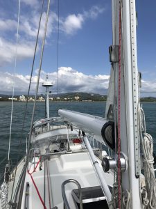
The instrument is basically a humongous dish antenna built into a huge crater in the haystack-shaped karst hills of Puerto Rico. The bowl is a reflector and the receiver is a 900 ton instrument suspended over the dish by giant cables strung between three towers rising around the rim of the crater. In the pic above, it is pouring rain as I’m sure it does every day at the observatory located in the upland rainforest.
To get to the observatory we drove for two hours up narrow, roller-coaster backroads peppered with deep potholes and blind corners. The good news: You drive on the right hand side of the road! Most of the way we were in a dense rainforest with few houses. Totally worth the trip!
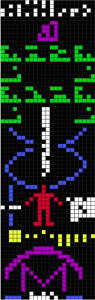
One last note: The Arecibo antenna was used to transmit a message intended for intelligent extraterrestrials. It did so twice. Below is a graphical representation of the message. Do you understand it without interpretation? Other than some recognizable symbols and some guessing, I didn’t. How are aliens supposed to understand this? Why not just send a picture of the Death Star, that way they’ll know we’re here but they’ll be on their best alien behavior…
If I Don’t Understand the Message, How Are Aliens to Understand?
Posted in Sailing by Mark with comments disabled.
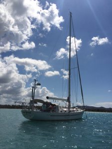
Back on the Boat!
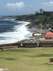
View from the Old Fort in San Juan
We just got back from a 2-week “vacation” to Colorado, visiting family, some friends and taking care of some business. It was somewhat frantic visiting so many people and it was mostly family. We couldn’t visit everyone we wanted to see this time, but of course we will be back again. Thanks to everyone who generously put us up for a night or few. We came back during the “return to winter” spring week and I actually had to shovel a foot of snow off a driveway to get out. Nice to have been back in Colorado, though.
We flew back through San Juan and stayed for a day visiting the old city. The pic above is part of the huge grass park outside fort San Felipe del Morro. Lots of cool architecture and brick streets in the old town, a fun tourist destination. Later in the afternoon we boarded a small “island hopper” plane to fly back to the east side of the island where Good Karma is docked. Here is a video from just behind the cockpit of us taking off from the San Juan airport. Those who know me know I love flying in these small planes. Every time I fly like this the desire to complete my pilot license wells up….
Our boat suffered no harm alone here in the Puerto Real marina while we were gone. Felt like coming back home. Today we took a walk to the beach and ran into the guy below. Back in the Caribbean!
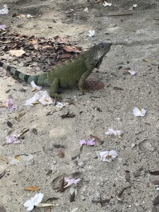
This Dude Was Walking on the Beach!
Posted in Sailing by Mark with comments disabled.
Puerto Real
YABS (Yet Another Beach Selfie), This Time at La Playita
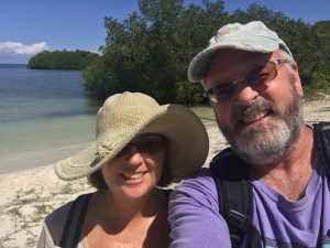
We are tied up at the marina at Puerto Real, just a bit north of Boqueron on the West Coast of Puerto Rico. It’s an interesting little town that reminds us of the many places we’ve been in South America. Kind of a heater-skelter assembly of streets, buildings and infrastructure that you don’t see much of in the states. Today we walked to the local beach La Playita which was a very clean tourist haven. We passed the local pizza parlor which we will visit in the coming days.
While Shelly has been extremely busy with her multiple programming projects, I got busy with some boat maintenance. Our jib furling winch has been “sticky” for a while so I decided to overhaul it. I will explain this below because that’s how I roll:
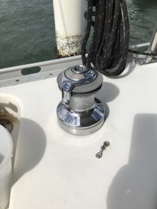
A Marine Winch
A winch is what you use to haul lines on a sailboat. The lines have heavy loads on them so you need some sort of mechanical assistance to adjust them. You wrap the line around the winch (the cylindrical thing in the photo above), and crank them tight using a handle, which is not shown but fits in the hole at the top of the winch.
Start by assembling the stuff in the pic below: A service kit, winch grease, a small paintbrush, a toothbrush, degreaser and light machine oil.
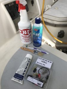
Winch Maintenance Stuff
Next, take the winch apart so it looks like this:
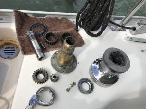
Remember How It Goes Back Together
Clean off all the old grease, replace the pawles, springs and collets. Put it back together not forgetting to grease the gears and oil the pawles. Done!
So now this is the list of skills I’ve acquired from living and sailing on S/V Good Karma:
- Winch Technician
- Refrigeration Tech
- Radio Tech
- Diesel Mechanic
- Rigger
- Marine Electronics Tech
- Communications Specialist
- Safety Officer
- Plumber
- Anchor Boy
- Hair Stylist
- Slave Laborer
Posted in Sailing by Mark with 1 comment.
Boqueron
S/V Good Karma Anchored in Boqueron Bay
Today is our last day at Boqueron, a big tourist/vacation center in PR, mainly for islanders as we have only met a few people from off-island. There is a nice beach to walk on and a small town with lots of restaurants, bars and gift shops. When we got here mid-week, it was pretty much dead quiet. That all changed on the weekend where the beach parties keep going until 2 a.m. The pre-Easter week is a big vacation week down here in PR so we expect there will be a lot of vacationers here next week.
The people here are friendly and it is very safe with the marine police station on shore here. There are a few other boats anchored here but most of them are empty, we’re not sure if they are abandoned or the owners are just out for a while. Today a boat came in from DR with some guys from back in the states, but those are the first cruisers we’ve met here in about a week.
The beer we have been drinking is called Medalla, brewed in Mayaguez. It turns out that Medalla Light is only available in 10-ounce cans (as opposed to 12 or 16 ounces you normally see), and has less alcohol than Coors Lite. We were wondering why we could drink so many and not notice much intoxication. Now we know why.
I’ve been able to get my morning run on the beach (yeah!) and Shelly has been working on her apps for her computer business and getting a lot done. You can swim in the water here but not snorkel as the water is too cloudy, so haven’t been doing much of that.
Yesterday I finally got the “reefer” (refrigerator) working again. I had to add refrigerant and re-set the thermostat sensors. I can now add “refrigerator tech” to my lengthening resume of skills that I have been compelled to learn on this boat.
We will be moving to a marina a few miles up the coast for a while, starting tomorrow.
Posted in Sailing by Mark with comments disabled.
Hangin’ in Mayaguez
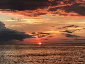
Mayaguez Sunset
Today we finally got it together enough to take Namaste in to Mayaguez and check out the town. Surprisingly, it was quite a large city that is well camouflaged from the bay. We got some new refrigerant to recharge our fridge, got a few staple food items (bananas, chips, whisky), and walked up to the university campus. The down is pretty run down as most metro areas are, but the campus is very nice. We stopped for lunch at a restaurant near the university. English is a second language here but just about everyone we ran into spoke a little. We got a lot of Spanish practice and even used Uber to get around.
We had a bit of an adventure getting back to the boat. The west wind picks up in the afternoon and was kicking up some significant waves. It was somewhat of a challenge getting Namaste off the dock in those conditions, but we had the help of three good samaritans. I wish I knew their names, they said they were there to “help tourists.” Well, they helped!
Tomorrow the plan is to sail south a bit to Boquron bay.
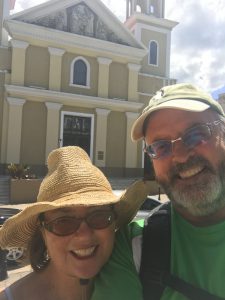
Shelly and I Outside the Church on Plaza Colon
Posted in Sailing by Mark with comments disabled.
Voyage to Puerto Rico, Part 3
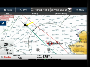
Rocking’ in the Mona Passage: Wind at 20 Knots, Vessel Speed 6.6 Knots, Waves 6 Feet!
Just before evening as we entered the Mona Passage, we saw our first whale! She did a vertical jump out of the water about 40 feet from the boat, just to get our attention. She then proceeded away, jumping out of the water about every 45 seconds, showing off. Cool!
I got the shortwave working again just as we were getting to the Mona Passage. The weather GRIB file showed the wind speed would be sustained up to 20 knots and from the northeast. This was fantastic news! Our weather window held and we could continue sailing at a fast clip. We were in for a wild ride.
The waves were also larger and so the boat was slamming up and down a lot, but we were moving fast. We got the majority of our motor-less sailing in the passage, moving over six knots much of the time. During one of Shelly’s night watches we were really moving, but she also was trying to avoid a big tanker seen on the AIS so she just kept going. She was amazed at how well the boat could do in rough conditions. I was trying to sleep at this time and it was not easy. The forward berth was like a noisy earthquake, rocking up and down, back and forth and when waves hit the hull it sounded like a war zone. The salon was tilted so far that I wouldn’t stay on the couch. Note to self: Need to come up with a tie-in for sleeping.
This video was taken the next morning after the waves had calmed down a bit but the wind was still around 20 knots. You can see how the waves occasionally break over the bow, this sounds like an explosion when you’re in the bow berth. The image from the chart plotter at the top of this post shows the wind and boat speed (trust me, it does), and the land mass of Puerto Rico to the right. Our boat is the black boat symbol in the upper left. The yellow arrow shows the direction of the wind hitting the boat. Despite the wild conditions, the weather was clear and sunny the next day and by the time the sun rose, you could see Isla Desecheo, part of the territory of Puerto Rico. If you look carefully, you can see the island in the distance in the video linked to at the start of this paragraph.
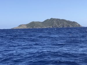
Isla Desecheo
Just as we passed the island, the wind and waves suddenly died down to nothing, being blocked by the land mass of Puerto Rico. We motored in to Mayaguez Bay and dropped anchor at 3 pm. We made it! And we both agreed, that was the most difficult passage we’ve done BUT, it really wasn’t that bad. As Shelly said, the conditions on climbing expeditions we’ve done was far more difficult. Well yes, but for sailing it was pretty hard. The worst thing for me was the inability to get a satisfying sleep and the fact that I have a hard time eating anything when the boat is rocking so much.
It’s been a long odyssey from Rock Hall to Puerto Rico, but we finally made it to the tropics. We’ll hang out in the Caribbean for possibly up to a year, but who knows? I hope now we can sail more with the wind than against it!
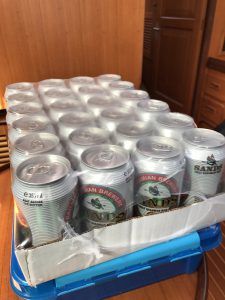
An Entire Case of Stocked-Up Bahamian Beer Remains Undrunk. What to Do?
Posted in Sailing by Mark with 4 comments.
Voyage to Puerto Rico, Part 2
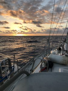
Sunrise on Day 2
It takes an entire day to sail around to the south side of the TCI banks. The islands themselves are only a small above-water area of the bank, which itself is quite large. The TCIs are geologically the southeast end of the Bahamas, which are the tops of big underwater mountains. As we turned more easterly, the wind picked up from the northeast and we put up our sails. We sailed on a port tack configuration for the duration of the trip and essentially it was a close haul during that time, meaning we were heeled over to the right all the way there.
Sleeping is always difficult for both of us while we’re on our rest breaks, but after the first night we were having an excellent sail as shown in this video I took as we were sailing into the morning sun. The wind direction was fantastic and we had full sails deployed. We still needed to motor to keep up a reasonable pace but we were doing well. On the second day the waves got a bit bigger but the wind was still constant and good as shown in this video. We were having a nagging issue at this point: I wanted to get an updated weather file and our shortwave would not connect. I looked at the antenna connection I made at Spanish Wells and found a small problem. I got that repaired but still couldn’t connect to my radio email.
On the second night we noticed a lot more commercial shipping traffic. We were rounding Cabo Tres Amarras in the Dominican Rep and all the shipping traffic headed for the Mona Passage rounds this point as well. We had to pay attention and keep out of the way of the ships as best we could. Fortunately we, an the big ships, had plenty of warning of each other thanks to the AIS.
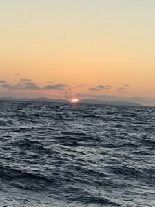
The waves picked up as we moved further down the Dominican Republic coast. So not only were we heeled to the right, we also had an increasingly bumpy ride. This makes sleeping difficult when you are off shift. We switched every three or four hours, trying to sleep when we could. You can imagine that after a few days of this you get a bit sleep deprived, but not too badly. The evening of the third night I took this video. If you look closely at the beginning, you can see the crescent moon setting over Samana, Dominican Republic.
Next post: The Mona Passage
Sunset Over the Dominican Republic
Voyage to Puerto Rico, Part 1
Anchored in Mayaguez Bay, Puerto Rico
We arrived on the East Coast of Puerto Rico yesterday afternoon! This was our longest and most difficult trip yet. We were both pretty tired after the journey that spanned four days and awoke after 14 hours of deep sleep to a beautiful, calm morning in the Bay of Mayaguez. Here is the story:
Back at the Turks and Caicos (TCI) we had been monitoring the weather forecast for an acceptable window to get to Puerto Rico (PR). The passage from TCI to PR is kind of tricky: It’s a fairly long route, over 400 statute miles. And the direction of travel is mainly east, against the easterly trade winds which can be quite strong. To review: If the wind is coming directly from your direction of travel, it is impossible to sail and very difficult to motor only, you move very slowly into waves that rock you around quite a bit. It’s not really practical for us to motor that distance in those conditions.
The trick is to wait for better wind conditions that do happen but are out of the norm. And since the trip takes several days, it’s less likely you’ll get favorable conditions for the entire passage. Plus, the weather forecast gets more shaky the further out you go. SO, you have to take a bit of a gamble when you commit.
If you look on a map you see the Dominican Republic lies along the route from TCI to PR. Lots of sailors stop there. That strategy has a few caveats though: You have to clear into the country which costs a few hundred dollars. Also, if you want any services, everyone expects a “tip.” Apparently this includes the official immigration people as well. An experienced friend told Shelly to “…offer them a shot and $20” to expedite the bureaucracy. Some may call this a “bribe,” but there it is called a “tip.”
The other problem is that all the stopover anchorages in the Dominican Republic are essentially just delaying the inevitable passage east. If conditions get too bad, these places are a good option to wait it out for the next window, but that may take a week or more to get that weather. If it takes two weeks, you may need to get to a marina to resupply, but guess what? Most of the water is undrinkable so you can’t put it in your boat water tanks without contaminating them. So for us, stopping there would kind of be a last resort as a haven if the weather deteriorated badly.
The best plan was to try to get to PR in one long sail. It would be about twice as long as anything we’d done to date. Adding to the fun, this passage was described as “…the most difficult passage to the Caribbean” that you could do. Much of the difficulty comes from the section known as the Mona Passage, which is the relatively narrow channel between the Dominican Republic and Puerto Rico. It is notorious for rough conditions and there are sections you want to avoid altogether. The conditions are caused by the Atlantic and Caribbean tidal currents running through extremely deep water before being forced up into relatively shallow water in the channel. Add wind to that and you can get some bad wave conditions, including large whirlpools. Giant commercial ships avoid these sections because they can be so bad. The other thing you have to look forward to is crossing at night. At the end of your trip. Yea baby!
So we waited for ourat the excellent TCIs for our window. A large low pressure system that threatened to become a tropical depression spun for many days just north of us. It just sat in one place and spun and spun. It caused the rain I described in my previous post here. This low pressure system was not really causing us bad weather any more but was generating huge waves that made it impossible to get out of the bay we were in. So we waited.
Finally we saw our opportunity. The window we were waiting for had materialized but the waves were still pretty big. We changed our planned route to go around the west side of the TCI bank instead of heading straight east. That way we would have only a couple hours of big waves while the bank would protect us for an entire day of sailing, at which time the waves would calm down a lot.
It took several hours to get going because we had to fuel up and wait for the TCI immigration people to come to the marina and “check us out.” In an airport, you go to them by waiting in a long line usually. On a boat they come to you, which is kind of cool.
We got going at 2 pm. We wove our way through the tricky shallow area behind the reef on the north side of Providenciales and exited through Sellar’s Cut. It was pretty wild with big breaking waves on either side of us as we went out.
More in part 2.
Posted in Sailing by Mark with comments disabled.
More Fun in the TCIs
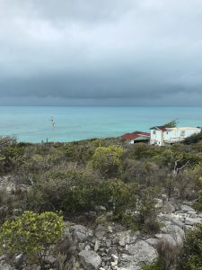
Storm’s a-Brewin’
Today we rented a car to get some chores done and visit other parts of the island. Laundry, propane tank refill, haircut (me), bought some Cuban cigars and visited an historical site. We are still here waiting for a weather window to move southeast, you can see the storm pictured above. But you know, I think I could live here. It’s the best place we’ve been since Vero Beach. Best meaning most civilized. By the way, I am including Riviera Beach, Florida, near West Palm Beach, as one of the lesser-civilized areas due mainly to crime and trashed-out cities.
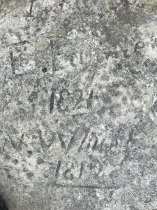
The historic place we visited was at the top of a hill where many of the early European pioneers of these islands had carved their names in rock. In the picture below you can see names and the years 1821 and 1819. There are more, supposedly some from the 1700s but we didn’t find them.
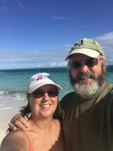
I got one of the best haircuts of my life at a local spot where all the dudes were speaking highly animated Spanish. I wish I understood them more, they were having a great time. It took the barber about a half hour to cut my hair and man did he pay attention to detail. Below is a pre-barber longhair shot of us at the beach:
I’d put my post-barber shot on the blog but I’m afraid I look too much like a male model and it would go viral. My server couldn’t handle the load and would crash…
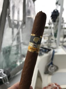
Anyway, I bought a few Cuban cigars: Cohiba, from Havana. Man are they good! All that stuff you hear about Cuban cigars is true. They are smooth.
What Winston Churchill (the Prime Minister) and I Have In Common
Turks and Caicos
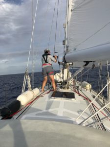
Shelly Hoists the Staysail Just Before Dusk on Day Two
Made it! This was our longest trip yet, taking about 50 hours to get from Cat Island to the Turks and Caicos Islands. Our weather window held out very much as predicted, allowing us to get here before the big storm that started today.
The final evening at Cat Island we went in to a local beach shack bar to spend our remaining Bahamian currency. We both had gotten a bit injured here: Shelly tweaked her back while we were hauling Namaste off the beach, and I exacerbated my knee “issue” by running a wee bit too far. Not a big problem, we would not be moving around much over the next few days.
Shelly wanted me to point out the resolution to a bit of a mystery we came across in the Bahamas. As we walked down roads, or as I was running down a road, cars would pass and tap their horns just as they passed you. It wasn’t a warning, they were already next to you when they honked. It sounded to us more like a “hello” honk, so sometimes we’d wave. Not a big deal but we wondered, why do this to obvious strangers? Was it a cultural thing? Yes it was, those cars were Jitneys, private vehicles offering you a ride for a few dollars. This is Uber before Uber. If you hold up your hand they’ll stop. Well, I held up my hand a few times thinking I was waving hello, and they did stop. I couldn’t figure out what was going on as I walked past them as they never said anything. They probably thought I was another stupid tourist. Which I was.
We hobbled away on Good Karma Tuesday morning right as a squall line was moving through. It was pretty rough at first with lots of headwind, rain, and six-foot waves breaking over the bow. The stormy seas went on for about four hours and then gradually settled down to near-calm conditions for the next day or so. We motored most of the way during this time.
We finally began to get favorable wind in the early afternoon of day two. We got about 6 hours of non-motor sailing that was fantastic. During part of that leg you could go below deck and it was so smooth and quiet you couldn’t tell you were sailing on the open ocean. Just before our second sunset we hauled up the staysail due to the high winds predicted to form that night.
The winds increased gradually but it never got too bad. As we got closer to the Turks and Caicos islands, the waves grew much larger and were coming from the open Atlantic, more abeam, causing Good Karma to rock and roll intensely. But we were also getting fantastic wind and did not need to use the motor during the last few hours.
Coming into to Turtle Cove Marina was tricky, so much so that the marina provided a pilot boat to guide us in around the complex reef system. Finally got tied up in a slip and since then the wind and rain has increased, over 25 knots today.
Our plan worked flawlessly. We were able to travel about 250 miles in good weather, avoiding the worst of the storms at either end of the journey.
Up next: The quirky Turks and Caicos Islands!